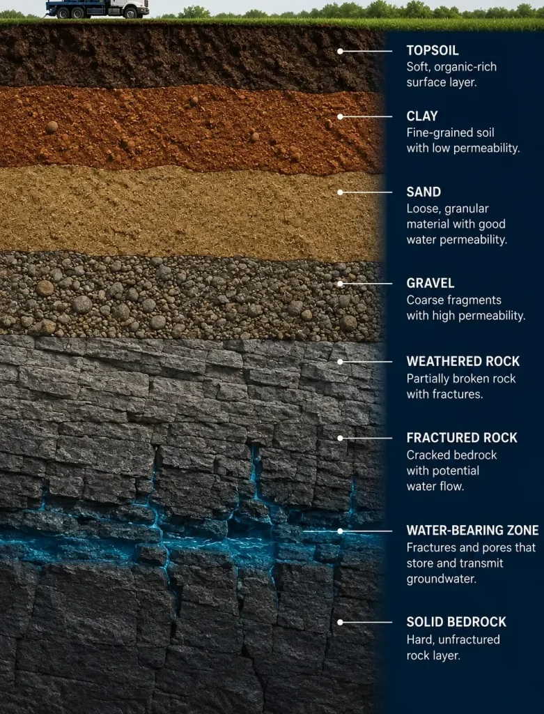
Seismic Groundwater Surveys Before You Drill
WaterFind USA uses advanced seismic technology to help evaluate possible aquifer depth, thickness, and groundwater potential before you commit to drilling a water well.
Traditional drilling confirms what is underground only after the cost of drilling has already begun.
A seismic groundwater survey provides additional subsurface information before drilling and can help compare possible drilling locations across a property.
WaterFind USA uses electro-seismology technology to collect and interpret signals associated with subsurface groundwater conditions.
The goal is to help property owners and drilling contractors make a more informed decision before selecting the final borehole location.
What Is Electro-Seismology?
Electro-seismology is a geophysical survey method used to collect information about subsurface geological and groundwater conditions. The method begins by creating a controlled seismic pulse at the ground surface. As that seismic energy travels through underground formations, interactions between the rock, sediment, groundwater, and electrically charged particles can produce measurable electrical responses.
Sensitive receiving equipment at the surface records these signals. The timing and characteristics of the recorded responses are then analyzed to help estimate potential aquifer depth, potential aquifer thickness, relative groundwater conditions, and differences between survey locations.
WaterFind USA uses this information as part of a pre-drilling groundwater site assessment.
Important: Electro-seismology provides estimated subsurface information. Actual groundwater conditions must ultimately be confirmed through drilling, well development, pump testing, and water-quality testing.
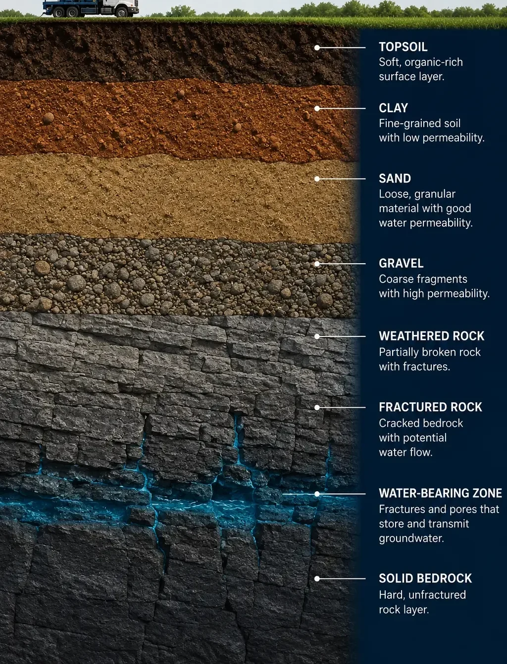
How a Seismic Groundwater Survey Works
Step 1- Select Survey Locations
Potential survey points are identified across the property. Locations may be selected based on property layout, existing well information, proposed well locations, access, geological conditions, and practical drilling considerations. Where appropriate, several survey points may be placed along a line to compare subsurface conditions.
Step 2 – Create a Controlled Seismic Pulse
A seismic source creates a controlled energy pulse at the ground surface. The pulse travels downward through soil, sediment, and rock. Different underground materials respond differently as the seismic energy passes through them.
Step 3 – Detect the Subsurface Response
When the seismic pulse interacts with water-bearing formations, measurable electrical responses can be generated. Surface sensors record these signals. The timing and form of the recorded responses contain information that can be analyzed for subsurface interpretation.
Step 4 – Estimate Aquifer Depth and Thickness
Because the seismic pulse requires time to travel downward through the subsurface, the timing of the recorded response can help estimate the depth of a possible groundwater-bearing zone. Signal characteristics can also provide information used to estimate the thickness of the interpreted aquifer.
Step 5 – Compare Survey Locations
Multiple survey points can be compared to identify stronger interpreted groundwater conditions, thicker potential aquifer zones, different aquifer depths, and weaker groundwater responses.
Step 6 – Select a Promising Drilling Location
Survey results are reviewed together with practical site conditions such as interpreted groundwater data, access for drilling equipment, property boundaries, utilities, septic systems, buildings, local setbacks, and terrain. The final drilling location should also be reviewed with the contractor responsible for constructing the well.
What Information Can a Seismic Groundwater Survey Provide?
Aquifer Depth
An estimated depth to potential water-bearing formations.
Aquifer Thickness
An estimate of the thickness of the interpreted groundwater-bearing zone.
Relative Groundwater Potential
Survey points can be compared to identify locations with stronger or weaker interpreted groundwater responses.
Potential Yield Indicators
Signal characteristics may provide information that can be used to estimate likely groundwater productivity. However, actual sustainable yield must be confirmed after drilling through proper well development and pump testing.
Possible Salinity Indicators
In some conditions, interpreted survey data may provide information related to groundwater quality or salinity. Final water quality must always be confirmed through laboratory analysis.
Why Survey Before Drilling?
Drilling a water well can represent a significant investment. Without prior site information, a property owner may select a drilling location based primarily on convenience, guesswork, nearby wells, dowsing, or visual assumptions.
A groundwater survey can help provide another layer of information before drilling begins. Possible benefits include comparing several drilling locations, estimating possible aquifer depth, identifying potentially thicker water-bearing zones, avoiding weaker survey locations, providing information to the drilling contractor, and improving pre-drilling planning.
The survey does not eliminate geological uncertainty. It is designed to help reduce uncertainty before drilling.
Seismic Groundwater Survey vs. Dowsing
Dowsing, sometimes called water witching or divining, traditionally involves using divining rods, forked sticks, metal rods, or similar hand-held tools.
WaterFind USA uses instrument-based seismic technology instead. The seismic survey collects measurable signals from the subsurface and allows multiple survey points to be compared.
The goal is not simply to indicate that groundwater may exist somewhere beneath the property. The survey is intended to provide interpreted information about possible aquifer depth, aquifer thickness, relative groundwater conditions, and potential drilling locations.
Seismic Groundwater Survey vs. Drilling
Groundwater Survey
The survey is completed before drilling. Its purpose is to gather information about possible subsurface groundwater conditions.
Water-Well Drilling
Drilling physically enters the subsurface and confirms the actual geology and groundwater conditions. Only drilling can ultimately verify formation depth, actual groundwater entry, well construction conditions, sustainable yield, and water quality. The survey supports the planning process. Drilling confirms the final result.
Why Multiple Survey Points Can Be Better Than One
Groundwater conditions can change across relatively short distances. One survey point may show a different subsurface response than another location only a short distance away.
For this reason, WaterFind may complete several soundings across the property. Survey points may be placed approximately along a line where site conditions permit.
Comparing multiple locations can help identify relative changes in aquifer depth, changes in interpreted aquifer thickness, stronger groundwater responses, weaker groundwater responses, and more promising drilling areas. The exact survey layout depends on the property.
Site Requirements for a Groundwater Survey
Undisturbed Native Ground
The preferred survey location should contain undisturbed native soil. Recently filled, excavated, graded, or heavily disturbed ground may affect survey conditions. Where practical, a location with native ground should be selected.
Avoid Excessive Large Gravel and Cobbles
The upper portion of the proposed survey location should not contain excessive large gravel or cobbles. Where a site contains difficult surface material, additional data collection or an alternative survey location may be required.
Customer or Representative on Site
The property owner or an authorized representative should meet the WaterFind surveyor on site to review proposed well locations, access, property concerns, survey points, existing wells, utilities, and other relevant site information.
Pickup-Truck Access
Each proposed survey location should be reasonably accessible by pickup truck. A cleared working area of approximately 16 feet by 8 feet is preferred. Remove or identify obstacles such as brush, trees, tall vegetation, stored materials, fences, or other obstructions when possible.
Keep Away From Electrical Power Sources
Survey locations should generally be at least 50 feet away from significant electrical power sources, especially underground electrical lines. Electrical interference may affect data collection.
Mark Underground Utilities
Before the survey, identify or mark underground electrical, gas, water, irrigation, communication, and other buried utilities.
How Far Apart Are Survey Points?
Where property conditions allow, survey points may be placed roughly 100 feet apart in a line.
This can provide a useful comparison of changing groundwater conditions across the site.
The spacing may be adjusted according to property size, terrain, accessibility, buildings, utilities, geological conditions, and customer objectives.
WaterFind determines the final survey layout based on actual site conditions.
What Should You Prepare Before the Survey?
- Property address
- GPS coordinates
- Property map
- Existing well locations
- Nearby well records
- Intended water use
- Proposed building location
- Septic location
- Underground utility locations
- Access instructions
- Preferred drilling area
If you already have a drilling contractor, their input may also be useful when selecting potential survey locations.
What Happens After the Survey?
After data collection, the survey results are interpreted.
The information can be used to compare the surveyed locations.
The property owner can then discuss the results with the drilling contractor.
The drilling contractor remains responsible for selecting the drilling method, constructing the borehole, installing casing, installing well screen where required, developing the well, conducting pump testing, and completing the well according to applicable regulations.
WaterFind’s role is to provide pre-drilling groundwater information to support the planning process.
Can the Survey Tell Exactly How Many Gallons Per Minute a Well Will Produce?
No pre-drilling survey can directly confirm the final sustainable output of an unbuilt well.
WaterFind’s seismic interpretation may provide an estimate of groundwater potential or likely yield based on interpreted aquifer conditions.
Actual well yield depends on aquifer permeability, aquifer thickness, fracture connectivity, well depth, borehole location, well construction, well development, pumping conditions, and seasonal groundwater conditions.
Final sustainable yield should be determined by pump testing after the well is completed.
Can the Survey Tell Exactly How Deep Water Is?
The survey can provide an estimate of potential aquifer depth.
Actual conditions may differ when the borehole is drilled.
Groundwater depth can also vary due to geology, seasonal recharge, drought, pumping, and local aquifer conditions.
For this reason, interpreted survey depth should be used as planning information rather than as an exact drilling guarantee.
Can the Survey Determine Water Quality?
A geophysical survey cannot replace laboratory water testing.
The survey may provide interpreted information related to groundwater conditions, but drinking-water quality can only be confirmed after the well is drilled and a water sample is collected.
A completed well may need testing for bacteria, nitrate, arsenic, iron, manganese, salinity, hardness, and other local contaminants.
Follow applicable state and local testing recommendations.
Frequently Asked Questions
What is The Stories Book about?
This exquisite compilation showcases a diverse array of photographs that capture the essence of different eras and cultures, reflecting the unique styles and perspectives of each artist.
How much does The Stories Book cost?
This exquisite compilation showcases a diverse array of photographs that capture the essence of different eras and cultures, reflecting the unique styles and perspectives of each artist.
When will The Stories Book be released?
This exquisite compilation showcases a diverse array of photographs that capture the essence of different eras and cultures, reflecting the unique styles and perspectives of each artist.
Are signed copies available?
This exquisite compilation showcases a diverse array of photographs that capture the essence of different eras and cultures, reflecting the unique styles and perspectives of each artist.
Got questions?
Feel free to reach out.
FIND US NOW!
We are based in Peris Valley, California. Email us today to discuss your project, request a customized estimate, and received a DocuSign Service Agreement to get started.
Toll-Free: +1 (877) 388-7388
Canadian Cell : +1 (403) 845-6676
Email: waterfind333@gmail.com